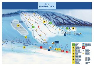
| Highest point: | 791 m |
| Lowest point: | 706 m |
| Altitude ski resort: | 758 m |
| Lifts in total: | 3 |
| Gondola lift: | 0 |
| Chair lifts: | 0 |
| Tow lifts: | 3 |
| Pistes in total: | 1.9 km |
|
Pistes:
|
1.3 km |
|
Pistes:
|
0.6 km |
Ski holidays Kašperské Hory – the golden town of the Bohemian Forest!
Kašperské Hory
Kašperské Hory (German: Bergreichenstein) is situated in Southern Bohemia at the upper part of Otava. It is embedded in the nature reserve Šumava and is surrounded by unique landscapes. The pretty town counts approx. 1,500 inhabitants and is dominated by colourful facades, a historic market square with a fountain, and impressive architecture, such as the dean church of Holy Margaret and the renaissance style town hall. Just above the town, the regional landmark, castle Kašperk (Karlsberg) rises above the town, and can be visited throughout the entire year. Border control and trade were already a key focus here in the Middle Ages. Back then Kašperské Hory was famous for its gold mining, extending right over to Bavaria in Germany. This is also the origin of the famous hiking trail "Goldener Steig" (golden trail) which runs along a main part of the trading route, right up to Passau. Besides skiing, tobogganing and winter hiking, there is also an exciting cultural programme with concerts, exhibitions and theatre to choose from.Bohemian Forest
The Bohemian Forest is a mountain chain which stretches over 200 km along the German-Czech-Austrian border. Although geographically speaking it is only a single mountain range, the name it's given depends on the region, i.e the political border. On the German side it's called the Bavarian Forest, it is known in Czech as Šumava and in Upper Austria it's given the name Bohemian Forest. The Czech part is at between 510 and 1,378 m above sea level, with the highest mountain, Plechý (Plöckenstein) being located on the Austrian border. In 1990 the UNESCO biosphere reserve Šumava was founded.Since the Middle Ages glass production has played a huge part in the region's economy and is known for this today. Tourism is now of increasing significance- also in winter. The Bohemian Forest is dotted with many small ski areas, each with its unique charm, so you really are spoilt for choice. All over you'll find soft slopes, often also with ski kindergartens for the little ones, to challenging pistes which lead through the wonderful forest landscape.
Travel Kašperské Hory
- By train: Sušice (approx. 20 km), Železná Ruda (approx. 35 km), Strakonice (approx. 40 km)
- By plane: Prague (approx. 160 km), Linz (approx. 165 km), Munich (approx. 200 km)


